The Town of Collingwood and its consultants EXP are excited to introduce a Traffic Calming and Active Transportation Feasibility project on Findlay Drive.
The objective of this project is to improve safety by reducing vehicular speeds through the implementation of physical and permanent traffic calming measures and leverage other feasible operational implementations related to Collingwoods’ Cycling Plan and Active Transportation Framework.
With Findlay Drive being identified as a Bicycle Priority Street, this is an opportunity to introduce on-street cycling facilities to improve active transportation connectivity and promote multi-modal activity.
Public input regarding the presented design recommendations is valued. Please participateContinue reading
The Town of Collingwood and its consultants EXP are excited to introduce a Traffic Calming and Active Transportation Feasibility project on Findlay Drive.
The objective of this project is to improve safety by reducing vehicular speeds through the implementation of physical and permanent traffic calming measures and leverage other feasible operational implementations related to Collingwoods’ Cycling Plan and Active Transportation Framework.
With Findlay Drive being identified as a Bicycle Priority Street, this is an opportunity to introduce on-street cycling facilities to improve active transportation connectivity and promote multi-modal activity.
Public input regarding the presented design recommendations is valued. Please participate in the review, voting option, and comment process to help deliver a critical piece of infrastructure.
Properties fronting Findlay Drive who are directly impacted by the proposed designs will receive a project information letter delivered to their door. Additionally, this information will be communicated via social media, radio, and newspaper to ensure residents are informed.
Proposed design options include several changes that vary between the given proposal options:
Option 1: Permanent Traffic Calming combined with joint use/shared travel lanes, painted bicycle sharrow markings on the roadway, and alternated parking.
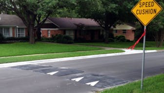
 Permanent traffic calming features, including three Speed Cushions across the full width of the roadway accompanied by signage (effective speed control device).
 Speed radar boards to remain in place for a minimum of six (6) months post-implementation to help monitor roadway activity and speeds.
 Minor geometric changes in line with corner bump-outs (curb extensions) associated with the proposed alternating on-street parking between Saunders Street and Hurontario Street.
 Various impacts to on-street parking regulations and/or removal as it related to Option 1 proposal.
Shared use roadway designation with sharrows. The implementation of this facility will extend throughout full length of the project. (High Street to Hurontarion Street)
Please view the full design concept for details.
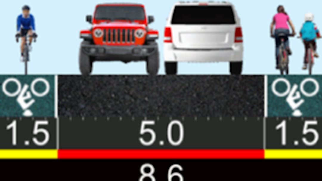
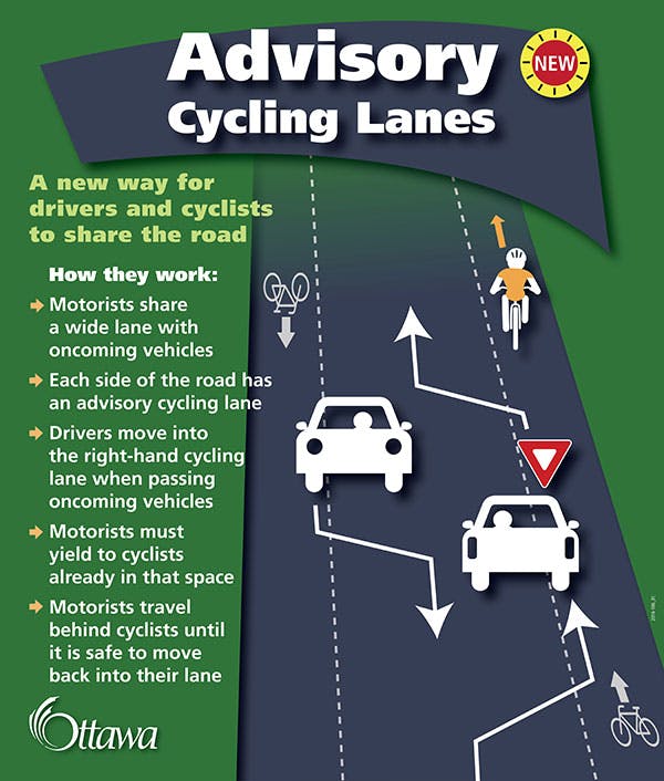
Option 2A (preferred): Permanent traffic calming with Advisory Bike lanes, improved pavement markings and signage.
 • Permanent traffic calming features including three Speed Cushions across the full width of the roadway accompanied by signage (effective speed control device).
- • Speed radar boards to remain in place for a minimum of six(6) months post-implementation to help monitor roadway activity and speeds.
- Implementation of 1.8m wide shared-use bicycle lanes on both sides of the road, delineated with a dashed/skipped while line, painted bicycle stencils outlined with green paint.
 • Shared Use Roadway designation with adequate signage and delineation.
• Complete removal of on-street parking and implementation of ‘no stopping anytime’ (NSA) parking restriction and signage.
Please view the full design concepts for details.
 • Enhanced pavement marking application to provide positive guidance and intersection delineation.
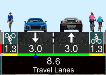
Option 2B: Permanent traffic calming and dedicated bike lanes.
 • Permanent traffic calming features including three Speed Cushions across the full width of the roadway accompanied by signage (effective speed control device).
- • Speed radar boards to remain in place for a minimum of six(6) months post-implementation to help monitor roadway activity and speeds.
- • Implement designated bike lanes - design considers 3.0m wide lanes with dedicated 1.3m bike lanes with centre line markings.
 • Complete removal of on-street parking and implementation of 'no stopping anytime' (NSA) parking restrictions and signage.
Please view the full design concepts for details.
Please use the quick poll below to vote for your preferred design option by September 29, 2023.
Review the preliminary design options here.